
Severe Thunderstorm Watch for parts of northwest Kansas
11 PM THURSDAY UPDATE:
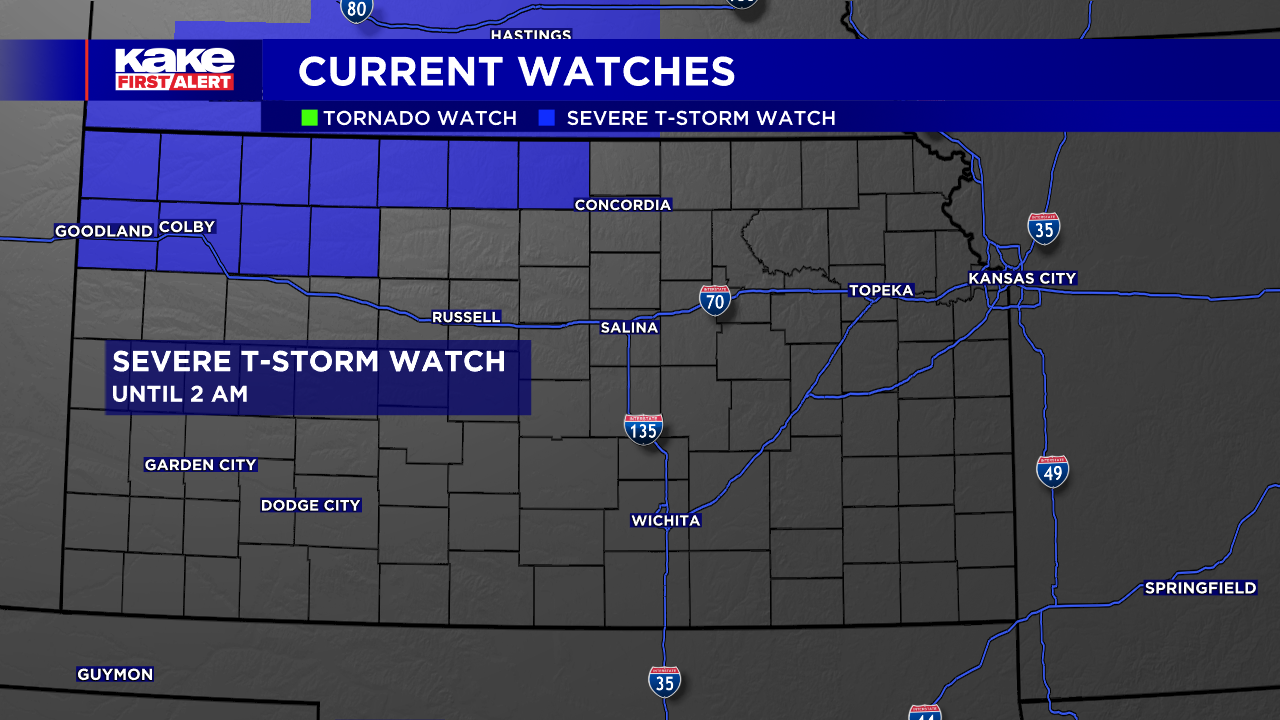
Our Tornado Watch has been downgraded to a Severe Thunderstorm Watch until 2am for a few counties in NW and NC Kansas. A few strong to severe storms are still possible through the early overnight hours. The main threat will be up to quarter-sized hail and 60mph wind gusts. Some showers and sub-severe thunderstorms will also move into south central KAKEland after midnight and linger into early morning. Another round of severe weather is possible for eastern Kansas Friday and then a greater chance for widespread severe storms Saturday. More details here.
THURSDAY PM UPDATE
A Tornado Watch until 10 p.m. CDT has been issued for 11 counties in northwest Kansas.
The watch includes the following counties: Cheyenne, Decatur, Gove, Graham, Logan, Norton, Rawlins, Sheridan, Sherman, Thomas and Wallace. Check KAKE's Interactive Radar here.
KAKE Meteorologist Cameron Venable reported earlier Thursday afternoon that the warm front was advancing north across western Kansas. Despite a strong cap, supercells and tornadoes are still possible, especially across northwest Kansas.
We’ll keep you up to date with our Interactive Radar and LIVE weather coverage. Get those features and more on the free First Alert Weather App. With the app you can track storms in your area, stream the latest forecast videos and live severe weather coverage, and set customized alerts to keep you and your family informed and safe.
THURSDAY AM UPDATE:
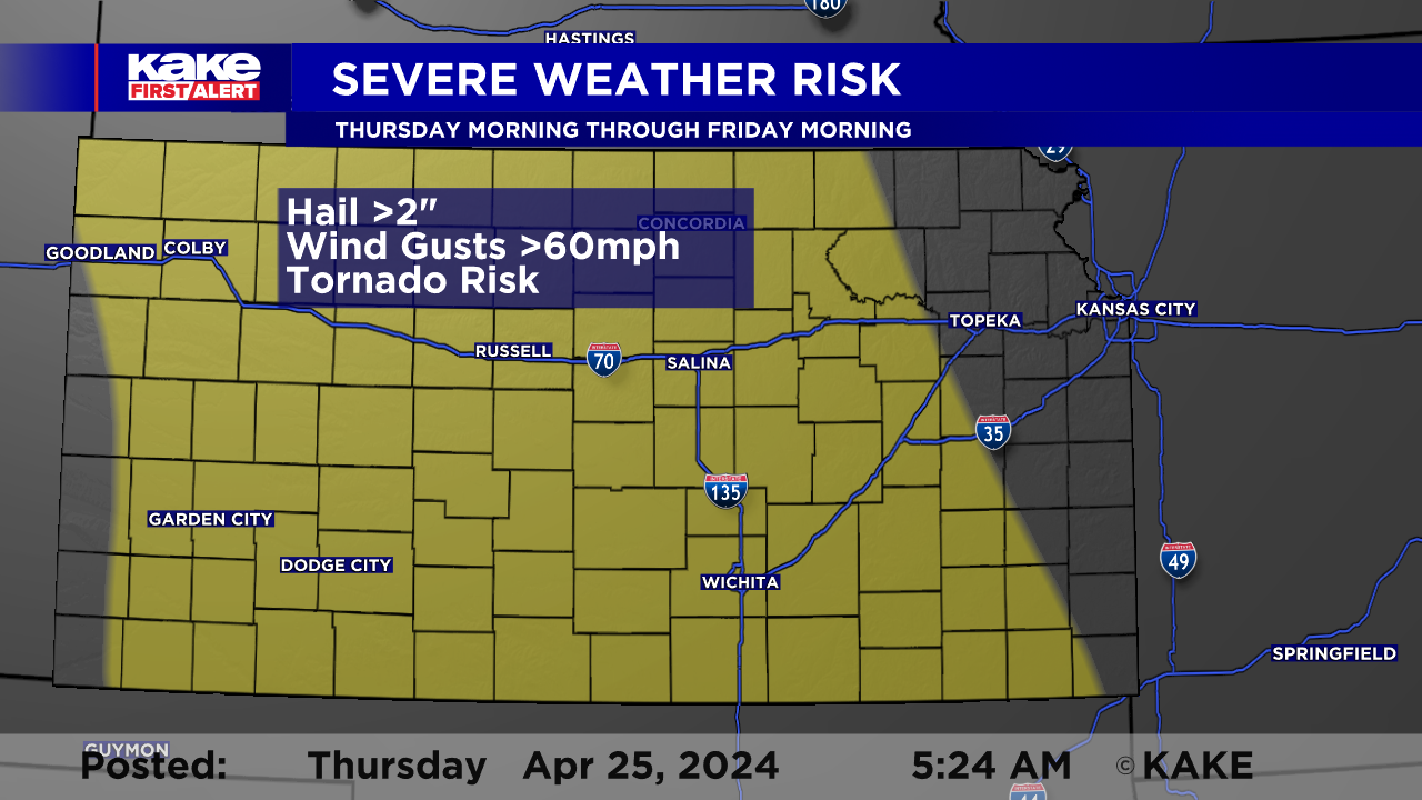
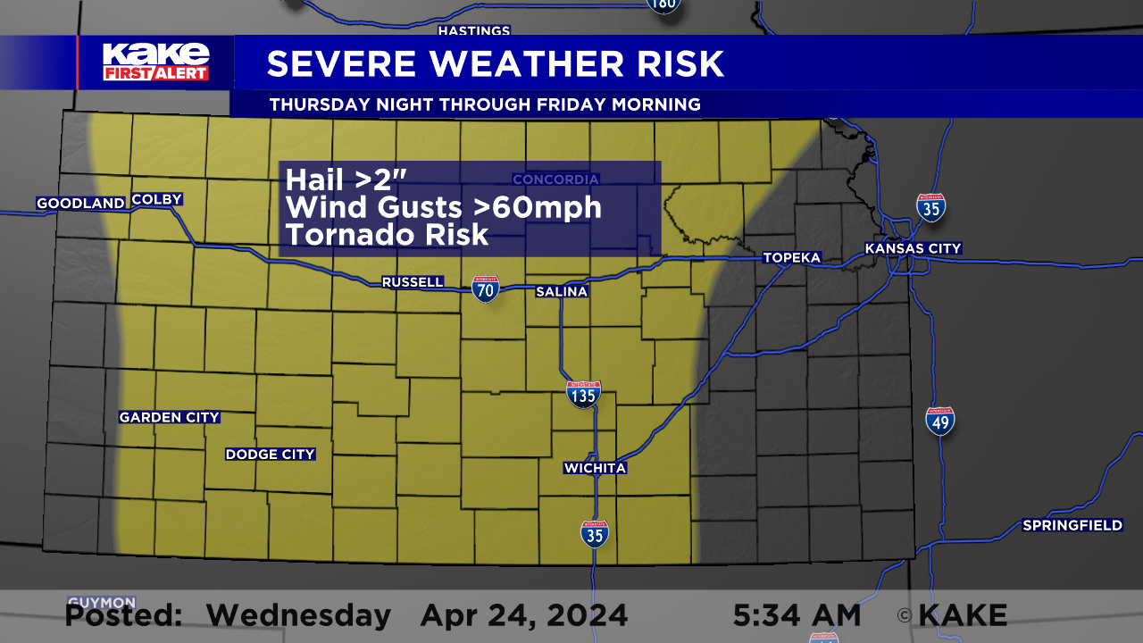
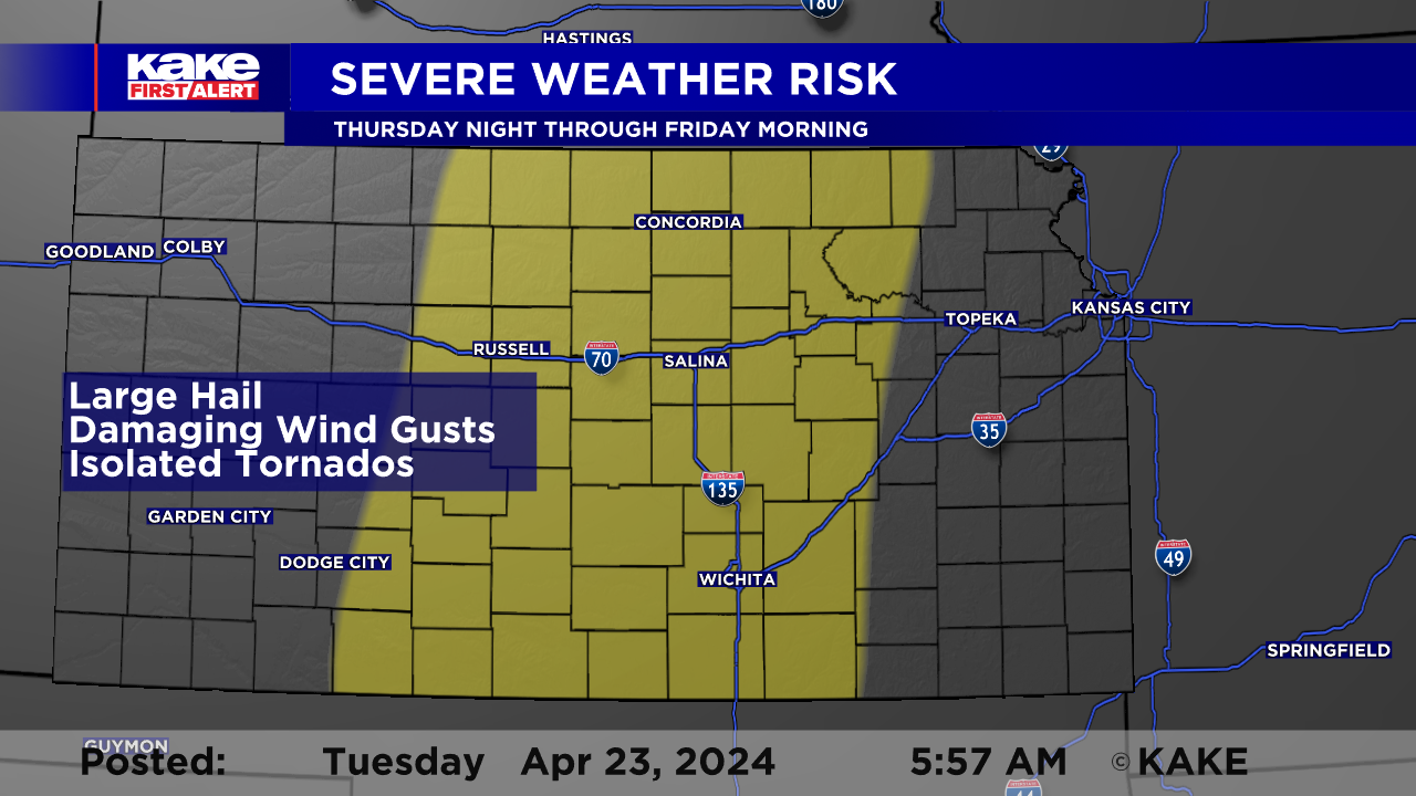
A busy end to the work week, with several rounds of strong and severe storms expected Thursday through Saturday. Over the three day stretch, we could experience; large hail over 2", wind gusts over 60mph, and even a few tornadoes!
As anticipated, a few storms early Thursday turned severe. The main threat, Thursday morning through the early afternoon will be storms that could produce hail stones to the size of quarters. This threat zone will stretch from North Central Kansas into Southeast Kansas.
The bigger threat on Thursday will be across Western Kansas, along a dry line. During the mid afternoon hours, storms are expected to fire up along this north-south line that will likely be positioned between US-83 and the Kansas-Colorado state line.
Storms will be forming in an environment very conducive to supercell development. Storms that are able to stay isolated will pose a very large hail threat, possibly larger than eggs (2"). In addition to hail high wind gusts and tornadoes will be a major concern.
This storm threat still remains what we call "conditional", meaning there is a chance that the "cap" or proverbial "lid" on the atmosphere may hold until very late in the day. though most weather models do depict isolated cells, there is always that chance that the atmosphere might win out and keep the storms at bay.
Provided to storms do develop, they are expected to track to the north and east through the late day hours and into the overnight. As the slide east, they may form into a line. As this merging occurs, the tornado threat will likely decrease a bit but the hail and wind threat will remain.
More storms will be possible during the overnight for North and South Central Kansas and they will need to be monitored close severe storm development.
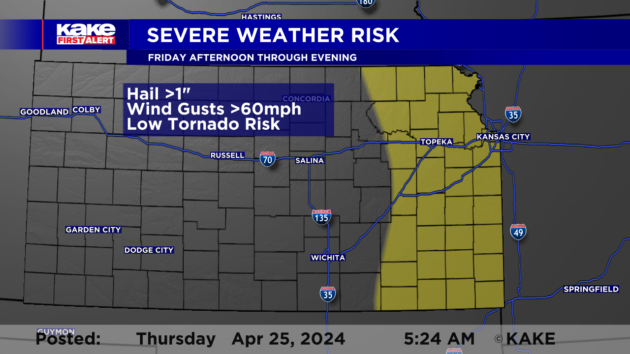
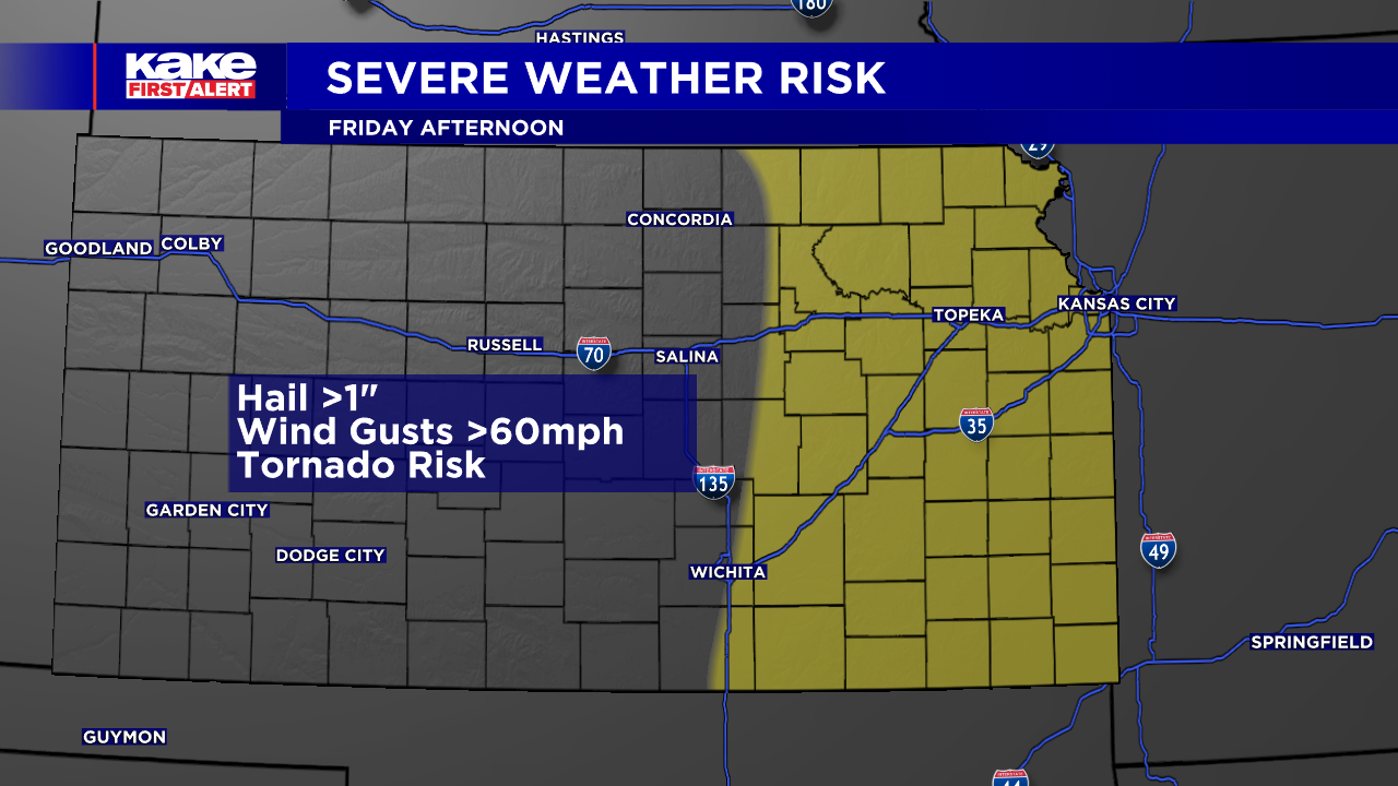
Another round of severe storms will be possible during the afternoon, Friday. The threat zone on Friday will be along a boundary that will be draped along the far, eastern edge of KAKEland. Afternoon storms along this boundary could turn severe with large hail over 1" in diameter (quarter size), wind gusts over 60mph and a brief tornado.
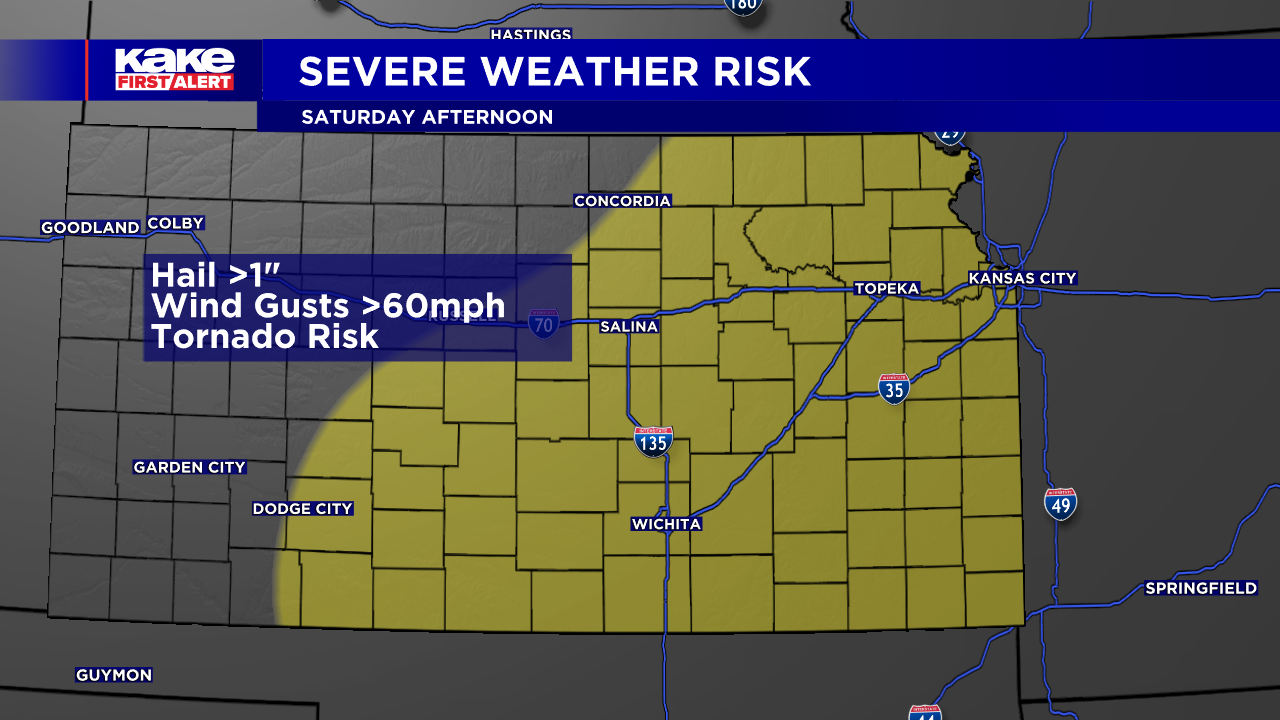
Late Friday through Saturday is expected to be relatively calm across KAKEland. The threat for severe weather will return during the afternoon hours on Saturday, especially across South Central Kansas.
Model depict storms developing in the early to mid afternoon across Oklahoma and South Central Kansas. These storms will then track to the northeast. The ingredients for severe weather will robust as temperatures soar into the 80s and dew points in the mid to upper 60s.
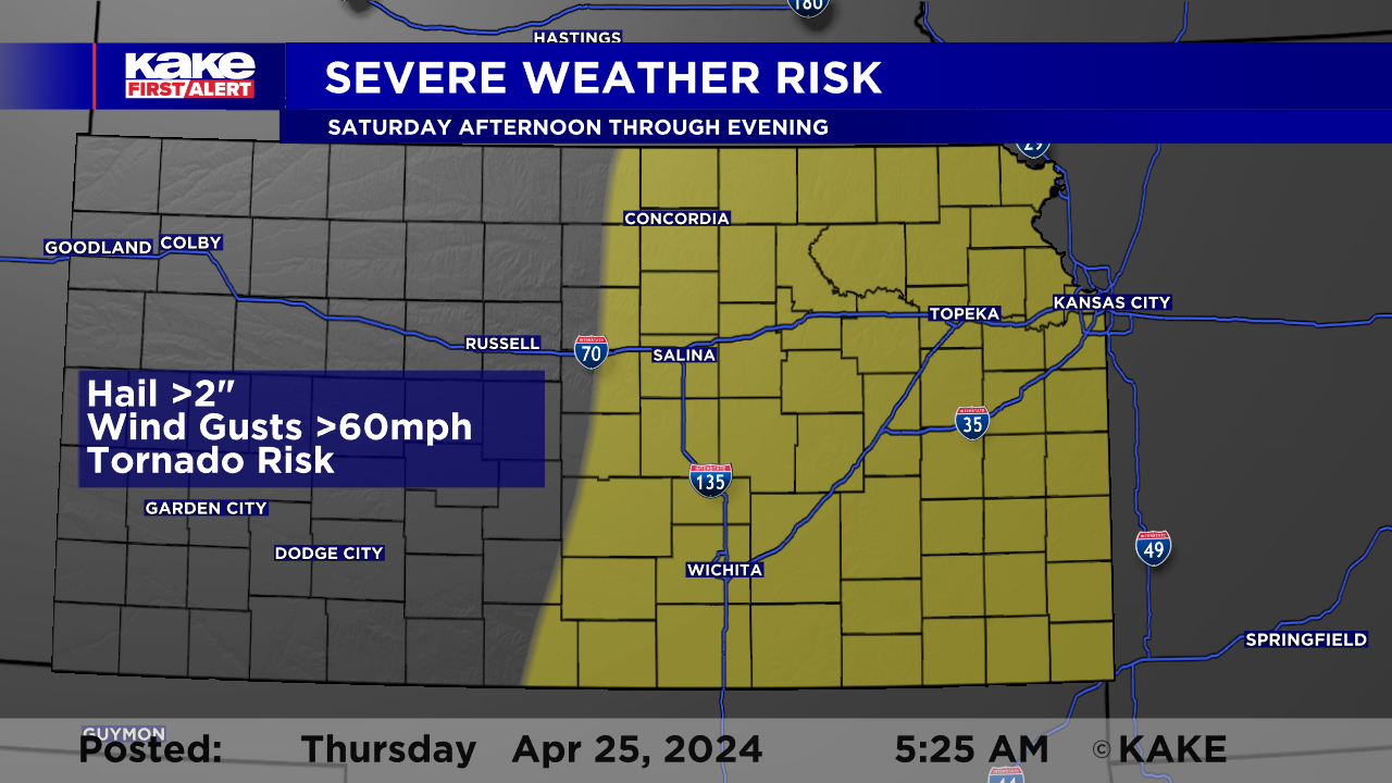
Storms on Saturday, could easily turn severe with hail stones that could top egg size (2") and possibly hit baseball size. Isolated storms will present a significant tornado threat.
The storms will likely disrupt activities during the afternoon and evening across South Central Kansas. Those with outdoor plans should have a severe weather plan in place should it develop. Having a reliable way of getting severe weather information is extremely important. The KAKE First Alert Weather app is a great tool, as is a NOAA Weather Radio. In addition to getting the alerts, it is also important to locate a nearby sturdy shelter should severe weather develop.
We’ll keep you up to date with our Interactive Radar and LIVE weather coverage. Get those features and more on the free First Alert Weather App. With the app you can track storms in your area, stream the latest forecast videos and live severe weather coverage, and set customized alerts to keep you and your family informed and safe. Watch the video below for information on how to set up the app to receive weather alert notifications.
In the event of severe weather, click here to follow KAKE First Alert Storm Trackers in the field.
WEDNESDAY PM UPDATE:
Not much has changed in the forecast regarding Thursday's storm potential. Isolated storms will try to develop in the 4-6pm time frame in western Kansas. If they can get fired up, they could very easily begin to rotate and try to produce a tornado. Initially, the tornado and hail threat will be largest. Then, as storms track east and form more of a line, damaging wind gusts will be the main concern.
Saturday still looks to be a slightly better severe weather day for parts of KAKEland. Details will become more clear for Saturday's event as we make it through Thursday. Continue to check back in on the forecast and stay tuned to KAKE during severe storms.
WEDNESDAY AM UPDATE:
Severe weather remains a concern, Thursday through Saturday as two storm systems track northeast across the Central Plains. Both systems could spark severe thunderstorms capable of producing large hail, high wind and tornadoes.
Thursday will likely start off with showers and storms on the radar. The morning storms may be strong and possibly even "low end" severe with hail to the size of quarters and wind gusts to around 60mph. The majority of the activity, Thursday morning, is expected to occur across the Eastern half of Kansas. This morning activity will likely, "disrupt" the atmosphere and make the environment a bit less favorable for late day severe storms.
While Eastern Kansas starts off with rain and rumbles, Western Kansas is likely to be dry and warm with highs climbing into the 70s and 80s. During the afternoon and evening a few storms may fire up along a north-south dry line. The atmosphere will likely be "capped" and the threat will be very "conditional". IF the storms develop, these storms will develop in an environment that could easily support supercells capable of producing hail stones over 2" (size of eggs), wind gust in excess of 60mph and a few tornadoes! There is the possibility that the cap, or "lid on the atmosphere" holds and this would likely reduce the number of storms that develop. While early storm development remains somewhat questionable, it is likely that a line eventually develops as the cold front tracks east.
Eventually, a line of storms will likely form and track east Thursday evening and into the overnight. Once the storms merge, the threats will likely shift toward high wind gusts, large hail, followed by brief tornadoes.
The severe weather threat should greatly diminish as we get into early Friday, but it will likely return during the afternoon/evening. The threat zone for Friday, will likely be east of I-135 and may not include Metro Wichita.
Another round of strong and severe storms will be possible across KAKEland on Saturday, and once again, large hail, high wind gusts and tornadoes will be possible. The details for Friday and Saturday will partially hinge on how Thursday plays out, so stay tuned for updates and alerts!
We’ll keep you up to date with our Interactive Radar and LIVE weather coverage. Get those features and more on the free First Alert Weather App. With the app you can track storms in your area, stream the latest forecast videos and live severe weather coverage, and set customized alerts to keep you and your family informed and safe.
In the event of severe weather, click here to follow KAKE First Alert Storm Trackers in the field.
TUESDAY AM UPDATE:
An active weather pattern sets up for KAKEland, as we head into the back half of this work week. While we could see some spotty, light rain Tuesday night into Wednesday, the better chances roll in Thursday through Saturday. Storms Thursday evening and overnight could turn dangerous with all forms of severe weather possible.
Thursday will likely start off with some activity on the radar, but it is not expected to be overly threatening. This morning storm activity could play a role in the development of afternoon strong and severe storms. It will be during the afternoon and evening hours, that the ingredients are expected to come together for severe storms. If a late day storm can break through the cap, or that "lid on the atmosphere", it could rapidly turn severe with very large hail, high wind gusts and even possible tornadoes.
After the initial thunderstorms, we may see them merge into a line or a secondary line form along the front. This possible, second round of storms, could also be severe with high wind being the most likely threat, followed by large hail and maybe a few brief tornadoes. The entire line is expected to slide east through the evening and overnight and the threat zone will likely include Wichita, late in the day and into the overnight.
Another round of rowdy weather possible on Friday, but most locations west of I-135 will likely be relatively tame. Additional storms possible Saturday into Sunday and they will also need to be monitored closely.
As with all forecasts, more details regarding timing and threats will become available as the event approaches. Like last week's severe weather threat, numerous ingredients will have to come together for this event, and like last week, minor changes can lead to major differences in outcomes. Stay tuned for updates and alerts.
Stay tuned for details as the forecast evolves. We’ll keep you up to date with our Interactive Radar and LIVE weather coverage. Get those features and more on the free First Alert Weather App. With the app you can track storms in your area, stream the latest forecast videos and live severe weather coverage, and set customized alerts to keep you and your family informed and safe.
In the event of severe weather, click here to follow KAKE First Alert Storm Trackers in the field.
