
Snow creates slick roads across KAKEland
Wednesday Morning Update:
Light to moderate snow is creating some slick spots across North and South Central Kansas. Accidents have been reported on I-70 west of Salina and across the Wichita Metro area as the morning commute has picked up. The majority of the problems have occurred on or near elevated roads.
Here's a look at some of the accidents Meteorologist Tony Laubach has seen::
Injury wreck involving a State Trooper on I-135 northbound at 77th Ave. No details at this time. @KAKEnews @KAKEweather #kswx #snow pic.twitter.com/EC622hCSUG
— Tony Laubach KAKE (@laubacht) January 22, 2020
Single-vehicle rollover wreck on 135th St north southwest of Maize. @KAKEnews @KAKEweather pic.twitter.com/PVambded85
— Tony Laubach KAKE (@laubacht) January 22, 2020
Jack-knifed semi on K-254 near Kechi, another car stuck in the median up the road from here. Slushy roads making for hazardous travel @KAKEnews @KAKEweather #kswx pic.twitter.com/Il8gUB8Dh6
— Tony Laubach KAKE (@laubacht) January 22, 2020
Drivers are encouraged to slow down and increase their following distance.
Here's a look behind the KAKE Studios at around 6 a.m. Be sure and give yourself a little extra time. Windshields won't be an issue since you can wipe them off easily, but there is some accumulation on the ground so watch your step around town this morning. pic.twitter.com/oX5Cszyq3T
— Austin Breasette KAKE (@AbreasetteKAKE) January 22, 2020
Road conditions will improve this morning as the snow and rain tapers off and temperatures climb further above freezing.
5:25 AM Wednesday Update:
Snow sticking to the lesser traveled parts of roads in downtown Wichita. This is pretty much the case city-wide. Watch for slush-spots on your morning commute. #kswx #snow @KAKEweather pic.twitter.com/pAJr1GFdr5
— Tony Laubach KAKE (@laubacht) January 22, 2020
5:00 AM Wednesday Update:
2:45 AM Wednesday Update:
Tuesday Afternoon Update
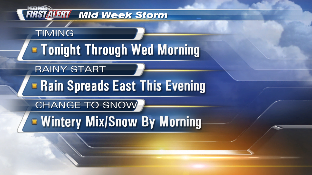
Rain and snow are on the way to KAKEland.
Rain showers have already moved into western Kansas and will continue to spread east into the evening and overnight hours. As temperatures cool this evening, that rain will change to snow and will continue into Wednesday morning before turning back to rain as the system exits on Wednesday afternoon.
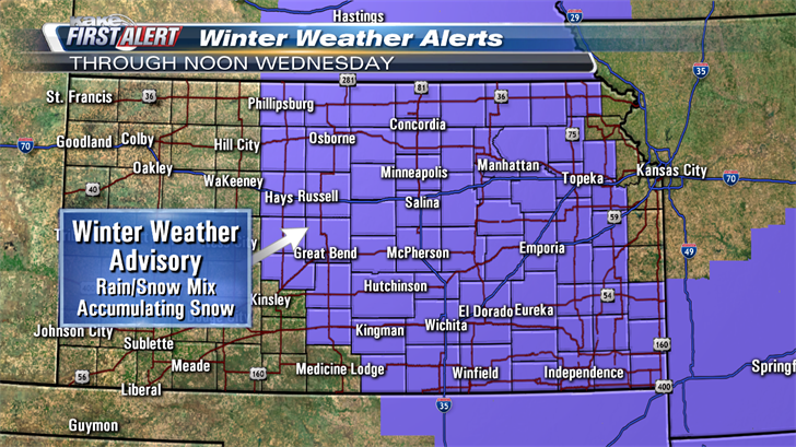
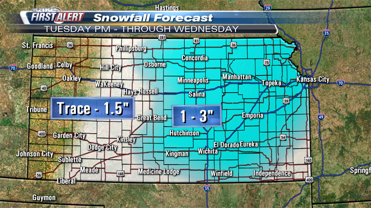
Winter Weather Advisories are in effect until noon Wednesday for greater Wichita, Hutchinson, and central Kansas. That advisory goes until 6PM on Wednesday for the far eastern KAKEland Counties. Current snowfall projections indicate widespread 1-2" with isolated amounts approaching 3" in the advisory areas. Wichita will likely see 1-2", but snow may have a hard time accumulating due to melting on the ground and light snowfall rates.
See weather alerts at kake.com/weatheralerts
Road conditions may get a little tricky during the Wednesday morning commute with slick spots developing on the usual suspects; bridges, overpasses, and on/off ramps. This snow will be a wet, heavy snow so slushy spots are also likely on roads. Be prepared for a slower commute Wednesday morning.
If cold air hangs around longer, it is possible we could pick up 3" in Wichita by Wednesday afternoon, still with the caveats mentioned above. Snow should start to come to an end mid-morning as it clears out from west to east. Areas across western KAKEland could see sunshine late afternoon.
Be aware that changes are still possible. Mixed winter events like this are very challenging and minor changes in temperature often lead to major changes in precipitation type and impact.
We’ll keep you up to date with our Interactive Radar and LIVE weather coverage. Get those features and more on the free First Alert Weather App. With the app you can track storms in your area, stream the latest forecast videos and live severe weather coverage, and set customized alerts to keep you and your family informed and safe.
Check Wichita road conditions at WichWay.org and check road conditions across the state at KanDrive.org.
