
Damage reported as storms, including tornadoes, roll through parts of KAKEland
SUNDAY MORNING UPDATE:
While power is being restored to the hardest hit parts of KAKEland, we have a compilation of images that have been submitted in the gallery above.
SATURDAY EVENING UPDATE:
Several tornadoes touched down in south central KAKEland, with reports of damage near Dexter, KS. So far, there are no reports of any injuries associated with any of these storms. Part of the Tornado watch that was issued for most of KAKEland was CANCELED for the following counties: Saline, McPherson, Harvey, Sedgwick, Marion and Chase.
A power pole in southeast Wichita was struck by lighting and snapped completely in half:

The Cowley County Emergency Management says damage reports have been made for only one property with damage to several outbuildings and isolated tree and utility line damage in rural areas.
SATURDAY AFTERNOON UPDATE:
The National Weather Service issued a Tornado Watch for the majority of KAKEland, including Wichita, until 7 p.m.
SATURDAY AM UPDATE:
Strong to severe storms are still in the forecast for today across a majority of KAKEland. Southeast KS has the highest potential for very strong thunderstorms, with the rest of Kansas expecting to see not as strong of storms, but still enough to definitely cause concern.

Large hail greater than 2" (around the size of an egg), wind gusts greater than 70 mph and a few tornadoes are all possible within these storms if they develop. All the ingredients are present for storms to develop, but we will need to break the "CAP" in the atmosphere in order to have storms. What is a CAP? It's a layer of warm air above cooler air, which prevents warm air from rising to create storms. It's basically a lid!
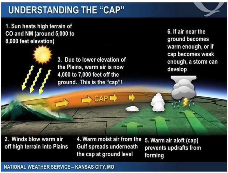
So yes, we will be fighting the "CAP" as we head into the second half of the day. But things could turn nasty very quickly if we are able to break it! Storms are expected to begin firing up as soon as 11 AM to 12 PM today and they will likely be lower end severe storms initially.

A warm front will lift northward as we head further into the afternoon and this will help storms fire up along I-70 in northern KS. Very warm and moist air in south central will help storms gain strength, and if they can stay separated, the risk for large hail and tornadoes will be much better.

Storms will continue to move through the area until around sunset, before the main line begins to move into eastern KS. A few scattered showers and storms will continue into overnight tonight, but those likely won't be on the severe side. Our main severe threat will be during daylight.
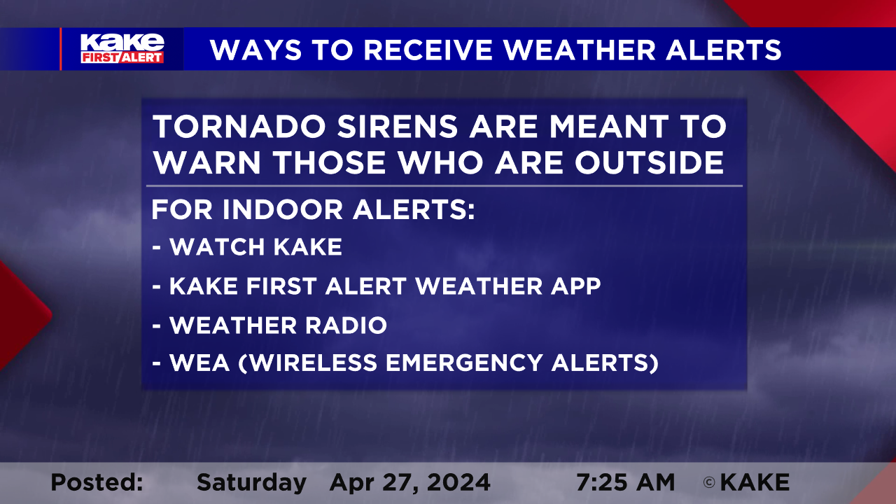
Please have SEVERAL ways to receive weather alerts and charge your electronic devices! We will be live on KAKE throughout the day to ensure you are updated and safe. We will also post updates on our social media and website.
Stay tuned for details as the forecast evolves. We’ll keep you up to date with our Interactive Radar and LIVE weather coverage. Get those features and more on the free First Alert Weather App. With the app you can track storms in your area, stream the latest forecast videos and live severe weather coverage, and set customized alerts to keep you and your family informed and safe.
In the event of severe weather, click here to follow KAKE First Alert Storm Trackers in the field.
FRIDAY PM UPDATE:

The severe weather risk, including the possibility of strong to violet tornadoes, continues for Saturday. Please stay weather aware and have a plan of action.
Saturday late Saturday morning, a few clusters of spotty storms will likely develop. A few of these may produce low-end severe threats, including 1” hail, and 60mph wind gusts.

As a line of anticipated storms interacts with a northward moving warm front across North Central Kansas, the tornado potential will increase.

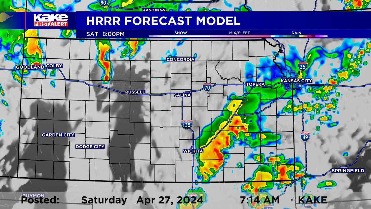
There is a capping layer that will try to prevent widespread thunderstorm development. Any storms that are able to sustain themselves and remain individual after sunset, will be within an environment favoring 2” or larger hail, greater than 60mph wind gusts, along with strong tornadoes.
This model image shows storms being suppressed. We will pay very close attention to all cells that manage to overcome the stable layer.
Severe storms should move out of KAKEland just after midnight.

FRIDAY AM UPDATE:
Two more rounds of storms on the way to KAKEland and both could turn severe, though the threat level with both is far from the same!
The majority of Friday will be relatively tame with the return of some sunshine. A few showers and storms possible through the day, with the greatest threat occurring across far Eastern Kansas, along the front during the afternoon hours. These storms may produce large hail, possibly larger than quarters (1") and wind gusts in excess of 60mph. Overall, the tornado threat in KAKEland appears to be relatively low at this time. Most of the activity late Friday, is expected to occur outside of KAKEland.

The severe weather threat is expected to return for the eastern half of the state Saturday. The day is likely to start off dry and if you have morning activities planned you should keep those. The concern greatly increases after the lunch hour, Saturday, with a round of early afternoon storms possible. These early afternoon storms could turn severe with large hail over 2", high wind gusts and possibly even a tornado or two.
Not unlike most severe weather events, this one also has some question marks surrounding it. One of the unknowns is how the early storms may impact the environment... if sufficient storms fire up early, it may disrupt the "severe weather ingredients" and that would lower the late day risk. Airing on the side of caution, at this time we are leaning toward another afternoon/evening round of storms that could quickly turn severe based on a recovered environment.
Cells that manage to stay isolated will present a very large hail threat, possibly topping 2"! These same storms could produce high wind gusts and tornadoes throughout the afternoon and evening. Storms will gradually slide east during the overnight hours and should decrease in intensity as we pass midnight. Spotty showers and storms, below severe criteria possible Sunday, especially in the morning hours.

It is very important to have a way of receiving severe weather alerts during the afternoon on Saturday! In addition to getting the alert, have a plan in place should you need to seek shelter.
Stay tuned for details as the forecast evolves. We’ll keep you up to date with our Interactive Radar and LIVE weather coverage. Get those features and more on the free First Alert Weather App. With the app you can track storms in your area, stream the latest forecast videos and live severe weather coverage, and set customized alerts to keep you and your family informed and safe.
In the event of severe weather, click here to follow KAKE First Alert Storm Trackers in the field.
THURSDAY PM UPDATE:
After a rowdy evening of storms for northwestern KAKEland, more severe storms are possible for parts of the state Friday and Saturday.

Our eyes are now mainly focused on Saturday's severe weather potential with the possibility for more widespread strong to severe storms. Another wave of energy looks to move into Kansas helping generate storms by mid-afternoon. Storms will be capable of producing large hail, damaging wind gusts, and potentially strong tornadoes.
Initially as storms develop, large hail and damaging wind gusts will be the main concern. However, in the early evening, the tornado threat will begin to increase, if storms remain isolated. Below is ONE example of what radar will possibly look like Saturday afternoon and evening. As the evening/night progresses, localized flooding will be a concern with areas of heavy rain possible, especially in southeast Kansas.


Before we get to Saturday, there is a smaller chance for severe storms Friday afternoon. Thankfully, most of Friday's storms will be outside of KAKEland, however, storms will likely develop right on the eastern fringe of KAKEland.

Stay tuned for details as the forecast evolves. We’ll keep you up to date with our Interactive Radar and LIVE weather coverage. Get those features and more on the free First Alert Weather App. With the app you can track storms in your area, stream the latest forecast videos and live severe weather coverage, and set customized alerts to keep you and your family informed and safe.
In the event of severe weather, click here to follow KAKE First Alert Storm Trackers in the field.
