
Dangerous wind chills continue across KAKEland
Click here to check Kansas road conditions and click here for closings and delays
THURSDAY 10:30PM UPDATE:
Here's a few of the snow totals, reported across KAKEland earlier today. Blowing and drifting makes snowfall measurement difficult.

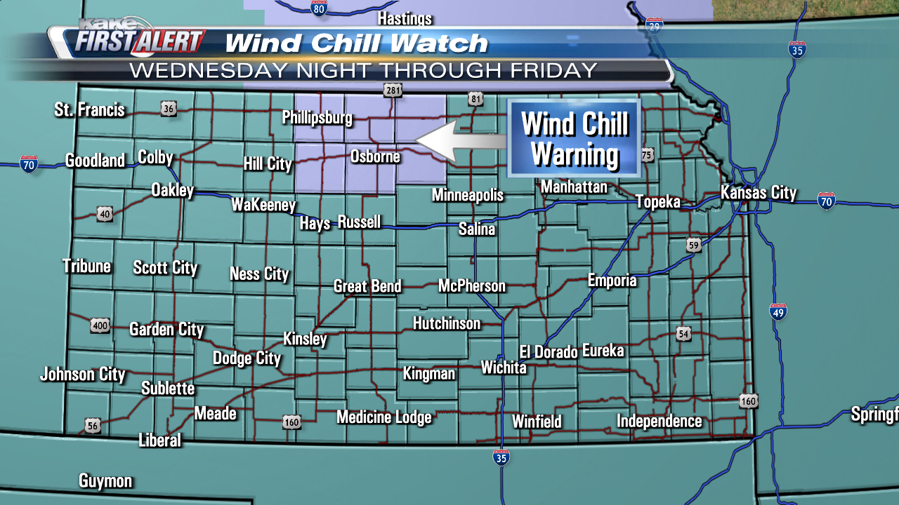
Thankfully, wind gusts will not be as high overnight Thursday night, into Friday. Regardless, overnight low temperatures and wind chills can lead to frostbite of exposed skin.


By Friday afternoon, temperatures will rebound well above 0°. Yet, wind chills will continue to be sub-zero temperatures, with the exception of Southwest Kansas.


THURSDAY 10:30AM UPDATE:
The heavy, blowing snow that prompted the Snow Squall Warning is quickly sliding southeast out of KAKEland. Most roads will gradually improve through the afternoon, though some may remain slick where the wind pushes the snow back on them.
Through the afternoon temperatures and wind chill values will remain dangerously low despite some sunshine breaking through.

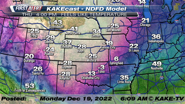
Wind chill values through the afternoon will generally be in the -20° to -30° F range.

Overnight, temperatures will once again plunge below the 0° mark!

Thursday 6:30AM Update:
While the wind gusts have let up a bit, temperatures continue to plunge across KAKEland! After experiencing numerous wind gusts up over 50mph, the gusts should settle generally into the 40 to 45mph range as we go through the day. Here's a look a the conditions across KAKEland as of 3AM:


THURSDAY 2:30AM UPDATE:
The cold front has swept across KAKEland and the temperatures are plunging! The tumbling temperatures as well as the light snow and wintry mist is making roads slick!
Here's a look at West Street and Central in West Wichita:
Here's a look at Central and I-235 in West Wichita:
WEDNESDAY MORNING UPDATE:
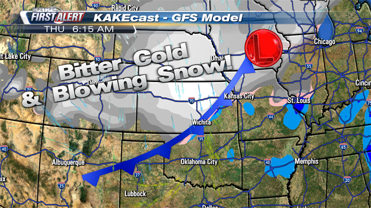
A very powerful cold front remains on track, moving into KAKEland late Wednesday into early Thursday morning. The cold front will bring dangerously cold air temperatures and wind chills, along with a quick hit of snow!
While snow often steals the headlines, the bitter cold and dangerous wind chills will be the most dangerous aspect of this week's weather.
TUESDAY EVENING UPDATE:
Cold & Dangerous Wind Chill are the primary hazards of this Arctic Blast. This cold blast is short lived but will be quite potent, -20 to -30F wind chills are likely but NW KS may see wind chills as low as -40F.

In terms of snow, numerical weather models continue to back off on snow totals. It seems the faster moving storm system is to blame as well as the best snow dynamics being outside of KAKEland. Regardless the snow amount, any snow that falls will be very hazardous due to the wind, whiteout conditions will be very likely especially during the morning commute. It's rather common, for Arctic Blasts to favor being cold, dry, & windy.


TUESDAY MORNING UPDATE:
The impending cold front is speeding up as it takes aim on KAKEland. Bitter cold and blowing snow still on the menu Wednesday through Thursday.
The approaching cold front will slide into Northwest and North-Central Kansas, Wednesday evening. Along the front some snow and blowing snow will be possible. In addition to the snow, temperatures will tumble with the passage of the cold front. The front will plow southeast through the evening with it reaching South Central Kansas and Wichita around the midnight hour. Light snow will be possible along the front with a slightly larger and heavier band of snow lagging the front, reaching Wichita in the early morning hours of Thursday.
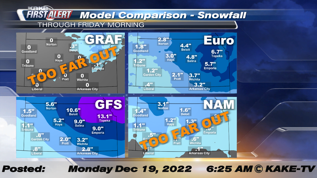
The snow is expected to be quick and weather models point toward relatively low totals across much of KAKEland.
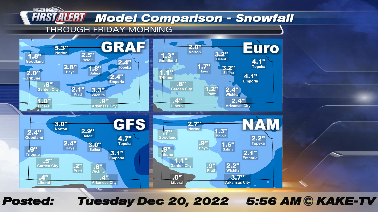
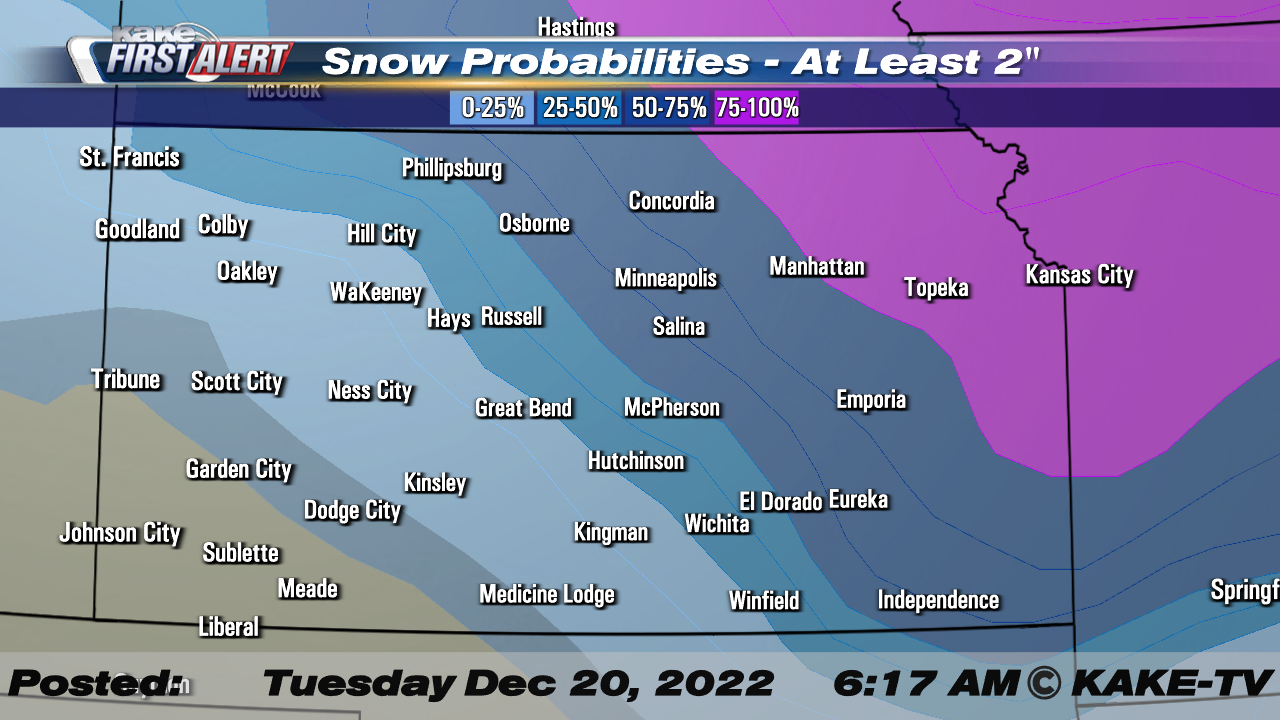
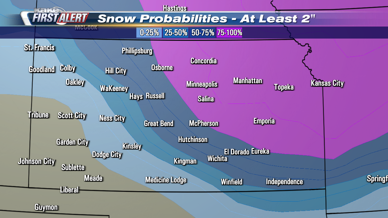
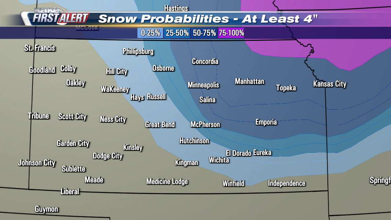
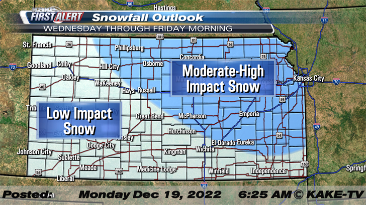
The Euro and GFS definitely lean toward higher totals across Northeast Kansas, while the GRAF and NAM appear a bit more mixed. While the placement of the heavier snow remains a bit in question, overall totals are not expected to be overly high for anyone in KAKEland. The probabilities from the National Weather Service Weather Prediction Center also depict higher totals across Northwest Kansas with totals over 2" looking very likely with Wichita landing in the 25-50% of 2" or more.
With this data in mind, we've places the slimmest totals across Southwest Kansas where less than 1" is expected. Most of KAKEland, including Wichita will land in the 1 to 3" band of snowfall with higher totals across Northeast Kansas.

The high wind with this event will likely make measuring the snow all but impossible! The blowing snow could also create blizzard conditions with very low visibility a concern late Wednesday through the day Thursday.
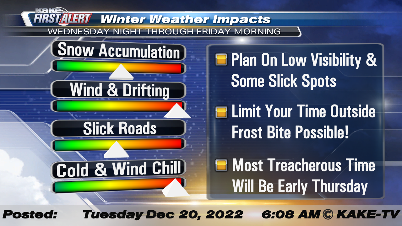
When it comes to slick road potential and low visibility the most treacherous time till be Wednesday Night through Thursday morning. While the cold will linger through the day Thursday, the snow will exit quick, and roads will likely improve during the afternoon.
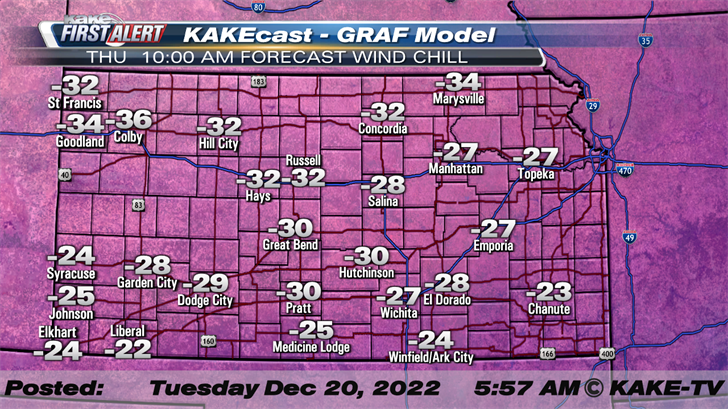
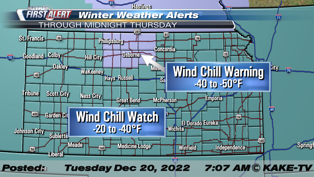
The wind and cold with this front will be extreme and dangerous for those who have to be outside. Wind Chills Thursday will range from -20° to as low as -40° F!
Because of the low wind chills, the National Weather Service has issued a relatively rare Wind Chill Watch and Warning for all of Kansas.
Travel is highly discouraged on Thursday. Those who do venture out, should make sure they have necessary supplies in their vehicle should they become stranded!
Stay tuned for updates and alerts. This forecast will evolve and become more specific as the event approaches.
We’ll keep you up to date with our Interactive Radar and LIVE weather coverage. Get those features and more on the free First Alert Weather App. With the app you can track storms in your area, stream the latest forecast videos and live severe weather coverage, and set customized alerts to keep you and your family informed and safe.
Check Wichita road conditions at WichWay.org and check road conditions across the state at KanDrive.org.
MONDAY EVENING UPDATE:
Not all that much change to the forecast, however, it seems latest model trends are shifting away from heavier snow to lighter snow amounts. The reason for this is that the main area of forcing is more so outside of KAKEland. Either way, even if you end up with snow, combine that with 40-50mph winds & we're talking about blizzard conditions. Regardless of the snow totals, the brutal cold & dangerous wind chills remain the primary story.
Monday started off with light rain and snow with even a little minor accumulation for some, the real blast of winter doesn't arrive until late Wednesday into Thursday. The mid-week punch will come in the form of a cold front, that will plunge temperatures, create dangerous wind chill values and could even bring snow and blizzard conditions!
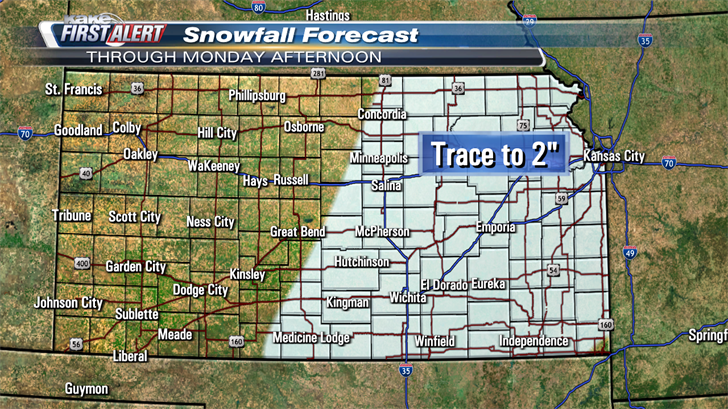
The rain and snow Monday will come to an end by mid-day with afternoon sunshine breaking through. A trace to around 2" of accumulation will be possible.
Early Monday morning, a photo from Belleville, Kansas from Jojo Boldt, showed some snow accumulation on the pavement.
Some isolated slick spots will be possible, early Monday but the vast majority of the snow is expected to melt upon contact with the pavement. Drivers should exercise caution and slow-down in areas where snow is accumulating on the roads.
Our next and more impactful blast of winter will roll into KAKEland, late Wednesday into Thursday. An area of low pressure rolling through the central plains will lift a warm front across Kansas on Wednesday. This front will allow temperatures to climb into the upper 20s to lower 30s during the day. Through the day on Wednesday, some minor snowfall will be possible, with minimal accumulation and impact expected.
The potent cold front will blast Southeast during the overnight Wednesday into Thursday. It is expected in the Wichita area, early Thursday before sunrise.
Temperatures across KAKEland, ahead of the front will be in the low teens to low 20s. After the front passes, temperatures will fall with afternoon "highs" around 0. Along with cold, wind gusts in the range of 40-50mph + can be expected. The combo of wind and cold will create incredibly dangerous wind chills in the -20 to -45 degree range!
Along with the cold, some snow is expected with this system. While it is still a little early to get specific when it comes to totals, early indications lean towards high totals occurring across North Central and Northeast Kansas.
With the high wind, any snow that we do get could reduce visibility greatly. The most treacherous driving conditions will likely occur in the areas receiving significant snowfall.
Blizzard conditions will be possible across a large swath of KAKEland, Thursday. It is important to remember that a blizzard does not necessarily mean, large quantities of snow. By definition, a blizzard occurs with blowing or falling snow with winds of at least 35mph, reducing visibility to a quarter mild or less for at least three hours.
Travel is highly discouraged on Thursday. Those who do venture out, should make sure they have necessary supplies in their vehicle should they become stranded!
Stay tuned for updates and alerts. This forecast will evolve and become more specific as the event approaches.
We’ll keep you up to date with our Interactive Radar and LIVE weather coverage. Get those features and more on the free First Alert Weather App. With the app you can track storms in your area, stream the latest forecast videos and live severe weather coverage, and set customized alerts to keep you and your family informed and safe.
Check Wichita road conditions at WichWay.org and check road conditions across the state at KanDrive.org.
