
Possible tornado causes damage near Pratt
After a possible tornado touched down near the town of Iuka, just north of Pratt, residents are left to pick up the pieces.
“I’m glad nobody was hurt,” resident Tim Hockenbury said.
KAKE’s First Alert Doppler indicated a rotational signature moving just north of Pratt at 3:29 p.m. Wednesday.
The town had no warning as 92 mile-per-hour winds blew through.
“I just heard a lot of rain and wind. You know, it was pretty substantial when it came through,” Hockenbury said.
Snapping power poles in its path, both on Highway 281 and in Iuka.
Debris was also found scattered around the highway.
“There were cars pulled over on the highway because it was pretty heavy rain. Little bit of hail,” resident Terry Stafford said.
A metal roof at the Iuka Coop was found bent and crushed.
And an overturned semi was found on Highway 281, just near where the tornado possibly touched down.
Residents said they’re just happy it wasn’t any worse.
“Trees are trees but you don’t want somebody to lose their home or somebody to get hurt. So, that’s the main thing,” Stafford said.
No injuries have been reported.
Previous story:
A possible tornado downed power poles and overturned a semi near Pratt as severe storms moved through parts of Kansas on Wednesday.
Winds topped 92 mph as the stormed rolled across US-282 just north of Pratt at around 3:30 p.m. No injuries were reported.
The National Weather Service says two tornadoes were reported in Ottawa County. There were no immediate reports of damage or injuries from that storm.
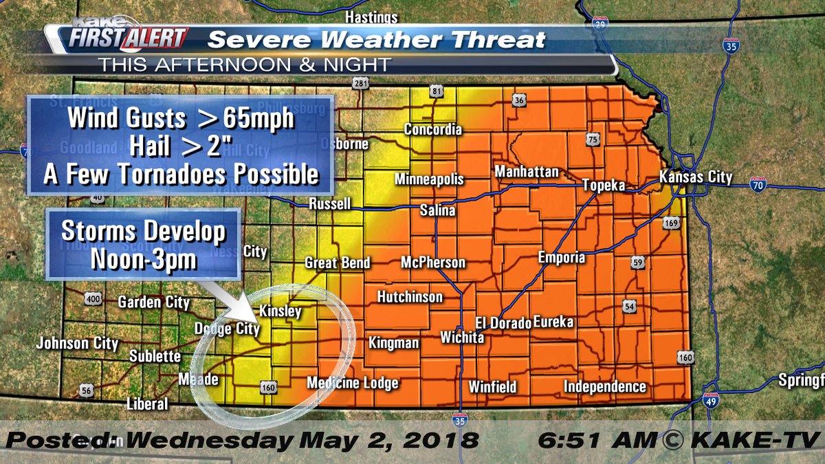
A Tornado Watch had been issued for a large swath of Kansas, including the city of Wichita.
The threat of severe weather came on the heels of 12 reported tornadoes reported in Kansas on Tuesday.
If you have storm pictures or video, post them directly on the KAKE-TV Facebook page or upload them on the KAKE First Alert Weather App.
With the Weather App, you'll have on-the-go access to our Interactive Radar and LIVE weather coverage, as well as forecast videos customized alerts and much more.
Click here to follow KAKE First Alert Storm Trackers in the field.
Previous story:
A severe weather threat for Wednesday currently covers a very large swath blanketing much of the eastern half of the state.
Storms on Wednesday are expected to initiate in the early afternoon near Dodge City, Meade, Kinsley, Greensburg and Coldwater. These storms will rapidly spread northwest toward Saint John, Sterling and Salina.
Large hail and high wind will be the most likely threats with a tornado or two not out of the question early on in the evolution of these storms. As storms merge into a line, the threat will shift more toward high wind gusts.
This entire line of storms will gradually slide east toward the I-135 corridor, reaching Wichita after 5 p.m. Storms will be exiting KAKEland between 11 p.m. and midnight.
 While storms and showers will still be possible on Thursday, the ingredients for severe weather will likely occur just east of KAKEland.
