
Tornado Watch issued for parts of Kansas
A Tornado Watch until 10 p.m. has been issued for dozens of counties in central and southern Kansas.
The watch includes the following counties: Barber, Barton, Butler, Chase, Chautauqua, Clark, Comanche, Cowley, Dickinson, Edwards, Elk, Ford, Geary, Greenwood, Harper, Kiowa, Lyon, Marion, Morris, Pawnee, Pottawatomie, Pratt, Reno, Riley, Saline, Sedgwick, Stafford, Sumner and Wabaunsee.
The National Weather Service received two tornado reports from northwest Edwards County at around 2:40 p.m. There were no immediate reports of damage.

The initial cells are expected to form before 3 p.m. These early cells will likely pose a slightly higher hail threat with stones that could top golf ball size. These early storms that remain isolated will also present a slightly higher tornado threat. Some additional storms, capable or producing a tornado may also develop along and ahead of the front into South Central Kansas. These storms will start moving south and east are expected to eventually merge into a line segment along and ahead of the advancing cold front. As storms merge the threat will shift from large hail and tornadoes to high wind gusts that could exceed 65 mph and the tornado threat will be greatly reduced.
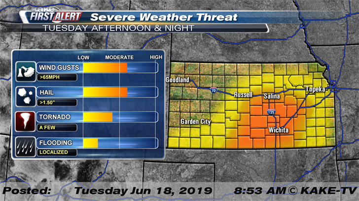
This line of storms is expected to plunge southeast quite rapidly and as a result, high wind damage will be a concern, especially across South Central Kansas, including Wichita. For this reason, we have highlighted an area on the threat map in orange. It is in this orange shaded area that severe weather looks most likely and will most likely be high wind gusts that could exceed 65 mph. At this point and time it appears storms will be most likely in and around Wichita between 6 p.m. and 9 p.m.
While torrential rain will likely accompany these storms, the quick moving nature of these cells will overall limit the flooding potential. Localized street flooding will be possible but should recede rapidly as the storms end. Severe storms are expected to exit KAKEland by very early Wednesday morning.
Some light rain will be possible as we head into early Wednesday morning across North and South Central Kansas. The second half of the work week is looking relatively dry and quiet across KAKEland as temperature climb back into the upper 80s to lower 90s.
We’ll keep you up to date with our Interactive Radar and LIVE weather coverage. Get those features and more on the free First Alert Weather App. With the app you can track storms in your area, stream the latest forecast videos and live severe weather coverage, and set customized alerts to keep you and your family informed and safe.
